Property surveying has evolved dramatically in recent years. Traditional tools - tape measures, spirit levels, and binoculars - remain essential, but modern technology now allows RICS surveyors to identify problems invisible to the naked eye, access dangerous areas safely, and provide clients with unprecedented detail.
As surveyors in Preston utilizing the latest surveying technology across Lancashire, we've seen firsthand how these innovations improve accuracy, safety, and client outcomes. This guide explores the technologies transforming property surveys and what they mean for home buyers and property owners.
Thermal Imaging Cameras
What is Thermal Imaging?
Thermal imaging cameras (also called infrared cameras) detect heat patterns and temperature variations across surfaces, displaying them as color-coded images. Different temperatures appear as different colors - typically blue/purple for cold areas, red/orange/white for warm areas.
How It Works in Surveys
When surveyors scan a building with thermal cameras, temperature anomalies reveal hidden problems:
What Thermal Imaging Reveals:
1. Missing or Inadequate Insulation:
- Heat loss through walls, ceilings, floors shows as warm patches
- Gaps in insulation clearly visible
- Thermal bridging identified (heat escaping through structural elements)
- Helps prioritize insulation improvements
2. Moisture and Damp:
- Damp areas appear cooler due to evaporative cooling
- Water ingress paths traced behind walls
- Identifies hidden leaks before visible damage
- Particularly useful for flat roofs and concealed pipework
3. Structural Issues:
- Temperature differences indicate cavity wall problems
- Detects air leakage through cracks
- Identifies areas where render has delaminated
4. Electrical Problems:
- Overheating electrical connections show as hot spots
- Circuit overload visible before failure
- Potential fire hazards identified
5. Heating System Issues:
- Blocked or air-locked radiators obvious
- Underfloor heating faults identified
- Pipe runs traced for maintenance/alterations
Real Preston Applications
Case Study 1: Victorian terrace in Ashton. Visual inspection showed no obvious damp. Thermal imaging revealed extensive cold patches on party wall indicating cavity saturation from neighbor's leaking gutter. Issue identified before purchase, seller made neighbor address problem.
Case Study 2: Modern house in Fulwood. Thermal scan showed missing loft insulation over 30% of roof space, not visible from loft hatch. Buyer negotiated £800 price reduction for remedial work.
Limitations
- Weather dependent: Temperature differential needed (doesn't work well in summer)
- Surface temperature only: Shows surface issues, not deep structural problems
- Interpretation required: Images need expert analysis
- Can't see through obstacles: Furniture, pictures can block view
Cost Impact
- Equipment cost: Professional cameras £3,000-£15,000+
- Survey cost premium: Typically £100-£200 additional if offered
- Value: Can identify issues worth thousands
Moisture Meters
Types of Moisture Meters
1. Pin-Type (Invasive) Meters:
- How they work: Two pins inserted into material, electrical resistance measured
- Accuracy: Very accurate for timber and porous materials
- Pros: Precise, localized readings
- Cons: Leaves small holes (negligible damage)
- Use: Confirming specific damp areas, timber moisture content
2. Non-Invasive (Radio Frequency) Meters:
- How they work: Radio frequency signals penetrate surface, moisture detected
- Accuracy: Good for screening large areas
- Pros: No damage, fast scanning
- Cons: Affected by metal (pipes, foil-backed plaster), salts
- Use: Initial surveys, walls with metal lath
What Moisture Meters Identify
- Rising damp: Ground moisture rising through walls
- Penetrating damp: Water entering from outside
- Condensation: Surface moisture from humidity
- Leak detection: Hidden plumbing leaks
- Timber decay risk: Wet rot develops above 20% timber moisture
Interpreting Results
Typical moisture meter readings:
- 0-15%: Dry, normal condition
- 15-20%: Elevated, investigate cause
- 20-25%: High, risk of rot developing
- 25%+: Very high, active damp problem
Beyond Simple Damp Detection
Modern moisture meters do more than just identify damp:
- Moisture profiling: Map extent of damp across walls
- Depth measurement: Some models show moisture at different depths
- Material-specific calibration: Accurate for brick, concrete, timber, plaster
- Data logging: Record and track readings over time
Preston Example
Edwardian semi in Ribbleton had "damp patches" on internal walls. Moisture meter readings:
- External wall base: 28% (very high)
- 1 meter height: 16% (elevated)
- Pattern consistent with rising damp
- Further investigation: Failed DPC confirmed
- Treatment cost: £2,400
Moisture meter data provided evidence for negotiating £3,000 price reduction.
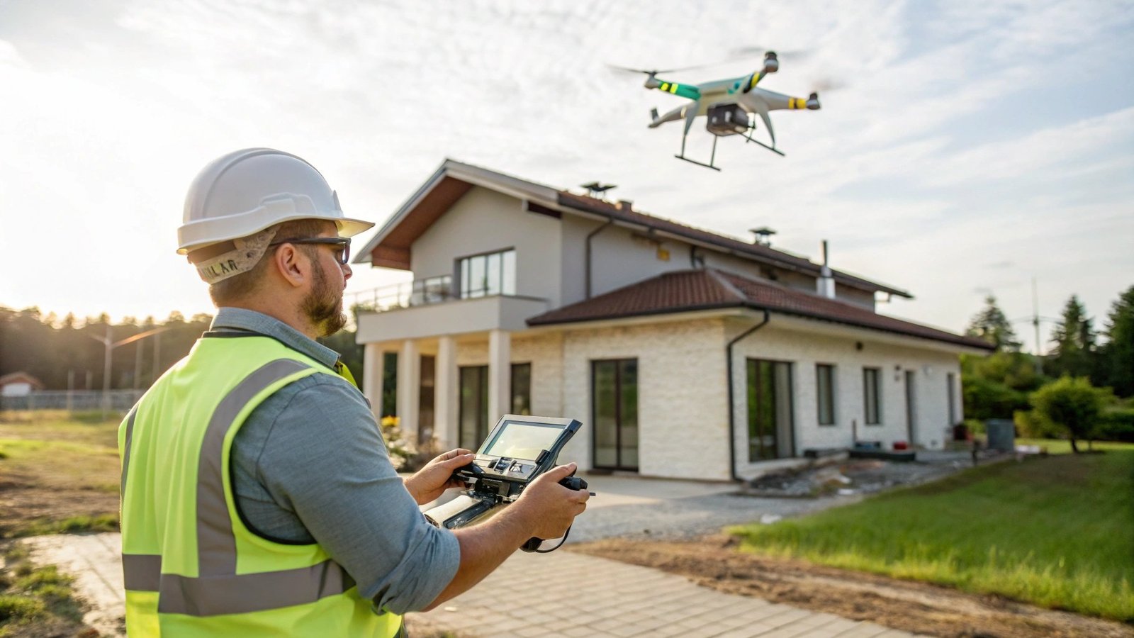
Drone Technology
Why Drones for Property Surveys?
Traditional roof inspection methods have limitations:
- Binoculars from ground: Limited view, miss hidden areas
- Ladders: Safety risk, limited access
- Scaffolding: Expensive (£500-£2,000+), time-consuming
Drones solve these problems:
- Safe inspection of dangerous areas
- Close-up views of roof, chimneys, valleys
- High-resolution photos and 4K video
- Fast and cost-effective
What Drones Inspect
Roofs:
- Missing, slipped, or broken slates/tiles
- Ridge tile condition
- Lead flashing deterioration
- Valley gutter problems
- Moss and vegetation growth
- Flat roof membrane condition
Chimneys:
- Pointing deterioration
- Leaning or unstable stacks
- Missing/damaged chimney pots
- Flaunching condition
- Flashing around chimneys
High-Level Elements:
- Gable walls
- Dormer windows
- High-level cracks
- Render condition on tall buildings
- Parapet walls
Large Sites:
- Commercial property overviews
- Site boundary surveys
- Tree proximity to buildings
- Drainage layouts
Technology Specifications
Modern survey drones feature:
- High-resolution cameras: 20+ megapixel stills, 4K/5K video
- Zoom lenses: Close inspection without proximity
- Thermal imaging: Some drones have thermal cameras
- GPS stabilization: Steady, precise positioning
- Obstacle avoidance: Safe operation near buildings
- Live video feed: Surveyor sees real-time footage
Regulations and Limitations
UK Drone Regulations:
- Operator must have CAA license for commercial use
- Insurance required (minimum £1m public liability)
- Restricted near airports (Preston near Warton affects some areas)
- Privacy considerations (permission needed for close property inspection)
- Weather dependent (wind, rain limit operations)
Limitations:
- Can't inspect inside buildings or lofts
- Weather-dependent
- Some roof areas still inaccessible (tight valleys, under overhangs)
- Can't assess structural integrity by touch
Cost and Value
- Professional survey drone: £1,000-£5,000
- CAA qualification: £1,000-£2,000
- Survey cost premium: Often included in comprehensive surveys; £100-£300 if separate
- Value vs scaffolding: Drone inspection £150-300 vs scaffolding £800-£2,000
Lancashire Application
Large Victorian property in Preston: Traditional inspection from ground identified some roof issues. Drone survey revealed:
- Valley gutter at rear (invisible from ground) had significant lead splitting
- Multiple slipped slates on rear slope
- Chimney stack north side had severe pointing loss
- Total repair costs: £4,200
Without drone inspection, these would have been missed until causing internal damage (likely £8,000+ total cost).
Borescopes and Endoscopes
What Are They?
Borescopes/endoscopes are cameras on flexible or rigid probes, allowing surveyors to see inside cavities, voids, and inaccessible spaces without destructive opening-up.
Survey Applications
Cavity Wall Inspection:
- Check cavity insulation condition
- Identify wall tie corrosion
- Look for debris/blockages
- Assess cavity width for insulation suitability
Underfloor Spaces:
- Inspect suspended timber floor voids
- Check for rot, woodworm, damp
- Assess airbrick ventilation
- Identify structural timber condition
Roof Voids:
- Inspect areas behind storage/insulation
- Check eaves ventilation
- Assess timber condition in inaccessible areas
Drainage:
- Internal pipe inspection
- Blockage identification
- Crack/damage assessment
Technology Features
Modern inspection cameras include:
- HD video: 1080p or 4K recording
- LED illumination: Built-in lights for dark spaces
- Flexible probes: Navigate bends and obstacles
- Waterproof: For drainage and damp areas
- Recording capability: Photo and video for reports
- Long cables: 5-30 meters reach
Preston Case Study
1930s semi in Cottam: Suspended timber ground floor. Limited access. Borescope inspection through airbrick revealed:
- Significant wet rot in floor joists under bay window
- Inadequate ventilation (airbricks blocked internally)
- Required £3,500 floor joist replacement
Visual inspection from outside wouldn't have identified this. Borescope saved buyer from major surprise.
Laser Measuring Devices
Beyond Tape Measures
Laser distance meters (laser measures) provide fast, accurate measurements up to 100+ meters with ±1-2mm precision.
Surveying Applications
- Room dimensions: Instant, accurate floor area calculations
- Ceiling heights: Measured precisely (important for loft conversions, etc.)
- Window/door sizes: Quick recording
- Level checks: Some models have inclinometers for slope measurement
- Large spaces: Commercial property measurements simplified
Advanced Features
Modern laser measures include:
- Pythagorean calculation: Indirect measurements (e.g., roof heights)
- Area and volume: Automatic calculation
- Memory: Store multiple measurements
- Bluetooth connectivity: Send data to tablets/computers
- Photo documentation: Built-in cameras with measurements overlaid
Benefits
- Speed: 10x faster than tape measures
- Accuracy: Eliminates human error
- Solo operation: No second person needed
- Safety: Measure dangerous or inaccessible areas
- Professionalism: Clients impressed by technology
Digital Reporting and 3D Visualization
Modern Survey Reports
Technology has transformed how survey findings are communicated:
Interactive Digital Reports:
- Clickable floor plans: Navigate to specific areas
- Photo galleries: Hundreds of images organized by location
- Video integration: Drone footage, thermal scans embedded
- Searchable: Find specific issues quickly
- Cloud access: View on any device
- Shareable: Easily send to contractors for quotes
Annotated Photography:
- Issues marked directly on photos
- Arrows, circles, labels identifying defects
- Before/after comparisons
- Thermal images alongside visible light photos
3D Property Models
Emerging technology creates 3D models of properties:
- Photogrammetry: Multiple photos processed to create 3D models
- Laser scanning: Precise 3D capture of spaces
- Virtual tours: Walk through property remotely
- Measurement from models: Take dimensions from 3D data
Applications:
- Planning alterations/extensions
- Remote client viewing
- Historical record of property condition
- Insurance claims evidence
CCTV Drain Surveys
Technology for Underground
CCTV drain surveys use waterproof cameras on motorized crawlers or flexible rods to inspect underground drainage.
What They Reveal
- Blockages: Location and cause (roots, debris, collapse)
- Cracks and breaks: Pipe damage from settlement or roots
- Pipe deterioration: Corrosion, wear, age-related failure
- Incorrect falls: Poor drainage gradient causing problems
- Connections: Verify drain runs and connection points
- Tree root ingress: Roots penetrating joints
When Recommended
Surveyors recommend drain surveys when:
- Property has history of drainage problems
- Visible settlement or cracking near drains
- Damp patches correlating with drainage routes
- Older properties (pre-1950 drains often deteriorated)
- Large trees near drainage runs
- Commercial property purchases
Cost and Value
- CCTV drain survey cost: £150-£400 typically
- Value: Identifies problems costing £2,000-£10,000+ to fix
- Negotiation tool: Evidence for price reduction
Preston Example
Victorian terrace purchase: Building survey noted damp in kitchen. CCTV drain survey revealed:
- Clay drain pipe under kitchen collapsed
- Constant seepage causing damp and subsidence risk
- Repair estimate: £4,800 (excavation and replacement)
- Buyer negotiated £6,000 reduction to cover repairs and disruption
The Future: Emerging Technologies
AI and Machine Learning
Artificial intelligence is beginning to assist surveys:
- Image recognition: AI identifies defects in photos
- Predictive analysis: Assessing deterioration rates
- Automated reporting: AI drafts report sections
- Comparative analysis: Benchmarking against similar properties
Augmented Reality (AR)
- On-site visualization: Overlay information on real-world view
- Hidden services: Show pipe and cable runs through AR
- Renovation planning: Visualize proposed changes
Advanced Sensors
- Acoustic sensors: Detect hidden water leaks
- Ground-penetrating radar: See below ground surfaces
- Radon detectors: Identify radioactive gas presence
- Air quality monitors: VOC, CO2, humidity tracking
Does Technology Replace Experience?
The Crucial Truth
Technology enhances but doesn't replace surveyor expertise.
Why Experience Still Matters:
- Interpretation: Data means nothing without expert analysis
- Context: Understanding building age, construction type, local issues
- Judgment: Deciding significance of findings
- Communication: Explaining complex issues to clients
- Holistic view: Seeing how different issues interact
Technology + Experience = Best Outcomes:
- Thermal imaging shows cold spot → Experienced surveyor diagnoses cause (missing insulation vs damp vs cavity issue)
- Drone reveals roof damage → Surveyor assesses urgency, repair method, cost implications
- Moisture meter reads 25% → Surveyor determines if rising damp, penetrating damp, condensation, or leak
Best practice: RICS qualified surveyor with modern technology and years of experience.
Should You Pay Extra for Technology?
When Technology Adds Value
Definitely worth it for:
- Complex roofs: Drone inspection essential
- Suspected damp: Thermal imaging and moisture meters clarify extent
- Older properties: Borescope inspection of cavities/voids valuable
- Drainage concerns: CCTV survey prevents expensive surprises
- Insulation assessment: Thermal imaging shows true performance
Less critical for:
- Simple, modern properties in good condition
- Recently surveyed properties
- Very tight budgets
Typical Costs
- Survey with thermal imaging: +£100-£200
- Drone roof inspection: Often included; +£100-£300 if separate
- CCTV drain survey: £150-£400 as additional service
- Borescope inspection: Usually included in comprehensive surveys
Conclusion: Better Surveys Through Technology
Modern surveying technology has revolutionized property assessment in Preston and across Lancashire. Thermal cameras reveal hidden damp and insulation issues, drones provide safe roof access, moisture meters quantify problems, and digital reporting makes findings crystal clear.
Key Takeaways:
- Thermal imaging identifies damp, insulation, electrical issues invisible to eye
- Drones enable safe, comprehensive roof inspection without expensive scaffolding
- Moisture meters provide objective evidence of damp problems
- Borescopes inspect cavities and voids non-destructively
- Technology supplements but doesn't replace surveyor expertise
- Cost premium typically £100-£300, often identifying £1,000s in issues
- Best results combine experienced RICS surveyor with modern technology
When commissioning surveys in Preston, ask what technology your surveyor uses. The combination of qualified expertise and modern tools provides the most comprehensive, accurate property assessment available.
Want a Technology-Enhanced Survey?
Our RICS surveyors utilize the latest surveying technology - including thermal imaging, drones, and advanced moisture detection - to provide comprehensive property assessments across Preston and Lancashire.
Book Your Modern Survey